Summary information
| Repository: | South Peace Regional Archives |
| Title: | Bezanson Family fonds |
| Reference code: | 0155 |
| Date: | 1906-1983 (date of creation) |
| Physical description: | 0.3 cm of textual records
183 photographs 12 postcards |
| Language: | English |
| Dates of creation, revision and deletion: | Processed by Mary Nutting 2004 Added to new database July 2024 – TD |
| Note: | This fonds has been identified as having Indigenous related content. Researchers may encounter language that is outdated and offensive. To learn more about Indigenous records at the South Peace Regional Archives please see our guide. |
| Note: | For detailed information about the photographs on the yellow linoleum squares, see accession information for fonds 0049. |
Administrative history / Biographical sketch
Ancel Maynard Bezanson, born near Halifax in 1878, began his love affair with the Peace Country in 1906. That year he traveled throughout the Peace with a camera and a notebook, and shortly thereafter published “The Peace River Trails” to promote the Peace River Country as a place to settle. He was convinced of the agricultural potential of the area, and returned for another scouting trip in 1907, and then to settle with his bride, Dorothy Robillard, in 1908. That winter, Dorothy died in childbirth, but her child (Frank) survived. In 1910, Bezanson married Dorothy’s sister Lois and the couple returned to the Peace Country. The couple lost twin girls and had one more son who survived (Jim).
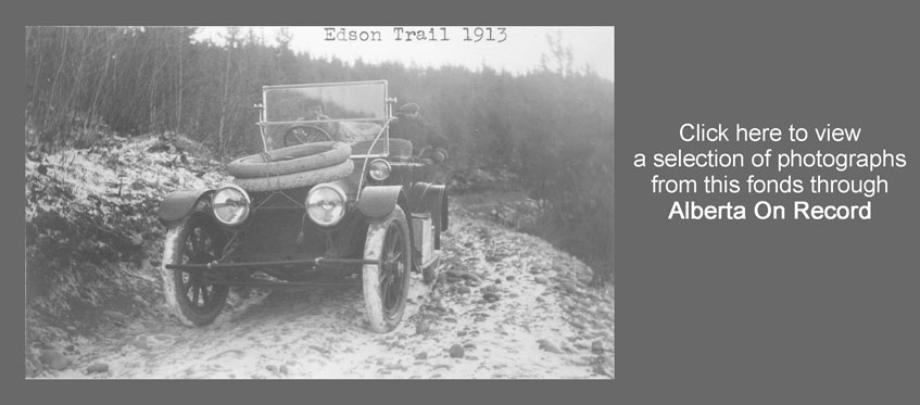
The Bezanson Ranch was called Teepee Ranch, but Bezanson also kept herds of cattle at Saskatoon Lake. When the C.N.R. Survey came through Teepee Ranch in 1908, Bezanson began to promote a townsite “along the railway” on a bench above the Smoky River. In 1913, Bezanson drove the first car over the Edson Trail. Accompanying him was A.J. Davidson, a real estate dealer from Edmonton, who supported Bezanson’s vision of a railroad and town.
In 1914 Bezanson published “Looking Ahead in the Peace Country—Building of a City’ with a detailed map of the Bezanson townsite. However, when the railroad finally came in 1916, it came to Grande Prairie. Bitterly disappointed, Bezanson left the area and finally settled at Pouce Coupe in 1931. His sons, Frank and Jim, also made their homes in British Columbia. Ancel Maynard Bezanson died in Vancouver on September 2, 1959.
Custodial history
The first donation of photographs were brought to the Peace Country by the Bezanson Family at the time the Old Bezanson Townsite was declared a historical site ca. 1986. They were left in the care of Janet Sarmaga, who later deposited them with the Grande Prairie Museum. In 2000 the records were transferred to the Grande Prairie Regional Archives.
In 2003, an accrual was donated to Grande Prairie Regional Archives by Mack Prentiss, son of Marion Prentiss and Mary Sheer. These photographs had been preserved by a cousin in Seattle who ran a rooming house. When an old man there died, she was asked to forward anything of value to his next of kin, and destroy the rest. She found the Bezanson pictures, and since they referred to Grande Prairie, she sent them to her cousin Mack Prentiss. They were copied by both the Daily Herald Tribune and the Provincial Archives of Alberta, but the originals were donated to this Archives in 2003.
In 2003, an accrual was donated to Grande Prairie Regional Archives by Mack Prentiss, son of Marion Prentiss and Mary Sheer. These photographs had been preserved by a cousin in Seattle who ran a rooming house. When an old man there died, she was asked to forward anything of value to his next of kin, and destroy the rest. She found the Bezanson pictures, and since they referred to Grande Prairie, she sent them to her cousin Mack Prentiss. They were copied by both the Daily Herald Tribune and the Provincial Archives of Alberta, but the originals were donated to this Archives in 2003.
Scope and content
The fonds consists of a collection of photographs donated by the Bezanson family when the Bezanson Townsite became an historical site ca. 1986; and a collection found in a Seattle rooming house in the 1970s. There is some duplication in the collection. They include photographs of Bezanson’s first trip into the Peace Country in 1906, their homestead on the Smoky River from 1908-1913, his 1913 trip over the Edson Trail in a 1912 Cadillac with an Edmonton Realtor named Davidson, the creation of the hamlet of Bezanson at the junction of the Smoky and Simonette Rivers, and a collection of Peace Country scenes dating from 1910 to 1930.
Notes
Title notes
- Source of title proper: Title of fonds based on contents.
Arrangement
Imposed order based on Bezanson’s publications and activities.
Restrictions on access
There are no restrictions.
Access points
- Textual record (documentary form)
- Graphic material (documentary form)
- Graphic material – photograph (documentary form)
- Family and personal life* (subject)
- Land, settlement and immigration* (subject)
- Exploration, discovery and travel* (subject)
Table of contents
0155.01, Bezanson Townsite collection, 1906-1933
0155.02, Bezanson’s First Trip to the Peace, 1906-1907
0155.03, A.M. Bezanson Homestead, 1908-[1915]
0155.04, Car Trip over the Edson Trail, 1913
0155.05, Peace Country Scenes, 1910-1914
Series descriptions
| Reference code | Title | Dates | Physical description |
| 2003.19.02 | Item – “The Peace River Trail” | 1907 | 1 booklet |
| Scope and content:
A 1987 reproduction of Bezanson’s trip over the Peace River Trail in 1906 documenting what he saw as a “land of promise” |
|||
| Series 0155.01: Bezanson Townsite collection
Date: 1906-1933 (date of creation) Scope and content: The series consists of 125 photographs portraying A.M. Bezanson’s first trip into the Peace Country in 1906, Teepee Ranch and all the activities there starting in 1908, Walter McFarlane’s survey crews which arrived in 1909, Bezanson’s trip into the Peace by automobile with A.J. Davidson in 1913, the making of the roads and townsite of Bezanson, activities on the Smoky River, The Beaver riverboat, the McFarlane family at Buffalo Lakes, and scenes from across the south Peace. There is also a copy of the booklet, “Looking Ahead in the Peace River Country to the Building of a City”, written by Bezanson ca. 1914. Physical description: 0.5 cm textual records 130 photographs Access points: • Textual record (documentary form) • Graphic material – photograph (documentary form) Arrangement: Most of these photographs are pasted to yellow linoleum sheets as they were formerly part of a museum display. In many cases they have two identifiers: one beginning with 1990.30 (indicating that it is part of the Bezanson fonds) and one beginning with 2001.02 (indicating that it is part of the display). Publication status: Published |
|||
| File / item list | |||
| Reference code | Title | Dates | Physical description |
| 0155.01.01 | Item – “Looking Ahead in the Peace Country to the Building of a City” Ancel Maynard Bezanson |
ca. 1914 | 1 booklet : 17 pp. |
| Scope and content:
Booklet by A.M. Bezanson presenting the reasons for the rapid development of the Peace River Country and arguing for the inevitable trend of this development to lead to the establishment of important trade centers. |
|||
| 1990.30.001 | Item – Settlers surveying the Grande Prairie Ancel Maynard Bezanson |
1910 | 1 photograph : b&w ; 3 x 5 in. |
| Scope and content:
A. M. Bezanson and party look over the Grande Prairie for likely homesteading sites. Note: 2001.02.066 |
|||
| 1990.30.002 | Item – Grande Prairie City Ancel Maynard Bezanson |
1913 | 1 photograph : b&w ; 3 x 5 in. |
| Scope and content:
A view of Grande Prairie City, as it appeared in 1913. Note: 2001.02.070 |
|||
| 1990.30.003 | Item – Grande Prairie, Alberta Ancel Maynard Bezanson |
1911 | 1 photograph : b&w ; 3 x 5 in. |
| Scope and content:
A distant view of hamlet of Grande Prairie in 1911. Note: 2001.02.067 |
|||
| 1990.30.004 | Item – An Automobile at Grande Prairie Ancel Maynard Bezanson |
1913 | 1 photograph : b&w ; 3 x 5 in. |
| Scope and content:
A.M. Bezanson with his automobile at Grande Prairie, Alberta in 1913. Note: 2001.02.069 |
|||
| 1990.30.005 | Item – First Crop, Smith & Sons Ancel Maynard Bezanson |
1908 | 1 photograph : b&w ; 3 x 5 in. |
| Scope and content:
First grain crop grown on the Grande Prairie. These grain stacks are on Smith & Sons farm. Note: 2001.02.063 |
|||
| 1990.30.006 | Item – Tea Party on the Grande Prairie Ancel Maynard Bezanson |
ca. 1911 | 1 photograph : b&w ; 3 x 5 in. |
| Scope and content:
A party of the first white women in Grande Prairie celebrating around an improvised tea table includes Lois Bezanson at far left. Note: 2001.02.068 |
|||
| 1990.30.007 | Item – Grande Prairie, Alberta Ancel Maynard Bezanson |
1910 | 1 photograph : b&w ; 3 x 5 in. |
| Scope and content:
In 1910, Grande Prairie was called Bear Creek and the only buildings were a “hotel” and a mission. Note: 2001.02.065 |
|||
| 1990.30.008 | Item – Make-shift Camp Ancel Maynard Bezanson |
1906 | 1 photograph : b&w ; 3 x 5 in. |
| Scope and content:
A party of settlers or surveyors having lunch at make-shift camp beside an abandoned log cabin. Note: 2001.02.062 |
|||
| 1990.30.009 | Item – Grande Prairie Before Settlement Ancel Maynard Bezanson |
ca. 1910 | 1 photograph : b&w ; 3 x 5 in. |
| Scope and content:
A. M. Bezanson and party standing on a sweep of the “grande prairie” before settlement c, 1910. Note: 2001.02.064 |
|||
| 1990.30.010 | Item – Indigenous woman standing in front of tipi, Lesser Slave Lake Ancel Maynard Bezanson |
1906 | 2 photographs : b&w ; 3 x 5 in. |
| Scope and content:
Two copies of an image showing an Indigenous woman and her baby standing in doorway of a tipi at Lesser Slave Lake. Note: 2001.02.248 |
|||
| 1990.30.011 | Item – Crossing Slave Lake in Winter Ancel Maynard Bezanson |
1908 | 1 photograph : b&w ; 3 x 5 in. |
| Scope and content:
The Bezanson party with teams and covered sleighs crossing Slave Lake in the winter of 1908 Note: 2001.02.249b |
|||
| 1990.30.012 | Item – Crossing Slave River Ancel Maynard Bezanson |
1906 | 1 photograph : b&w ; 6 x 3 in. |
| Scope and content:
John Revillion and Bill Short push their loaded canoe across Slave River in 1906. Note: 2001.02.249a |
|||
| 1990.30.013 | Item – On the Banks of Lesser Slave River Ancel Maynard Bezanson |
1906 | 1 photograph : b&w ; 3 x 5 in. |
| Scope and content:
John Revillion and Bill Short with their loaded canoe resting on the banks of Lesser Slave River in 1906. Note: 2001.02.250 |
|||
| 1990.30.015 | Item – First Car on the Edson Trail Ancel Maynard Bezanson |
1913 | 1 photograph : b&w ; 5 x 3 in. |
| Scope and content:
The first car on the Edson Trail in December, 1913. Note: 2001.02.245 |
|||
| 1990.30.016 | Item – Starting From Edson by Automobile Ancel Maynard Bezanson |
1913 | 1 photograph : b&w ; 5 x 3 in. |
| Scope and content:
Loaded car starting down the Edson trail on December 9, 1913 from in front of the Edson Grocery Company. Note: 2001.02.241 |
|||
| 1990.30.017 | Item – On the Edson Trail Ancel Maynard Bezanson |
1913 | 3 photographs : b&w ; 3 x 5 in. |
| Scope and content:
Three copies of an image showing A.M. Bezanson, in a coonskin coat, with the Cadillac he drove over the Edson Trail in 1913. The man on the right was the owner of the Cadillac. Note: 2001.02.243 |
|||
| 1990.30.018 | Item – North of House River on the Edson Trail Ancel Maynard Bezanson |
1913 | 1 photograph : b&w ; 3 x 5 in. |
| Scope and content:
A.M. Bezanson’s loaded car on the Edson Trail, 6 miles north of the House River. Note: 2001.02.246 |
|||
| 1990.30.019 | Item – 120 Miles Down the Edson Trail Ancel Maynard Bezanson |
1913 | 1 photograph : b&w ; 5 x 3 in. |
| Scope and content:
A.M. Bezanson and his automobile at mile 120 on the Edson Trail. Note: 2001.02.244 |
|||
| 1990.30.020 | Item – Driving The Edson Trail Ancel Maynard Bezanson |
1913 | 1 photograph : b&w ; 3 x 5 in. |
| Scope and content:
A.M. Bezanson enroute with the Cadillac he drove over the Edson Trail in 1913. |
|||
| 1990.30.021 | Item – Edson Trail by Automobile Ancel Maynard Bezanson |
1913 | 1 photograph : b&w ; 5 x 3 in. |
| Scope and content:
Loaded car on the Edson Trail in 1913. Note: 2001.02.247 |
|||
| 1990.30.022a | Item – [Bezanson on Winter Road] Ancel Maynard Bezanson |
1913 | 3 photographs : b&w ; 3 x 5 in. |
| Scope and content:
Three copies of an image showing a man in a Cadillac on a snowy road. Each copy has a different caption on the back:”Winter road Grand Prairie to Grouard.””Cadillac trip Dec. 1913. Picture taken by A.M. Bezanson.””Doing an Indian winter road in a Cadillac Dec. 1913.” |
|||
| 1990.30.022b | Item – Winter Road Ancel Maynard Bezanson |
1913 | 1 photograph : b&w ; 3 x 5 in. |
| Scope and content:
Image shows three men standing near a car on a snowy road. The caption under the photograph reads “Winter Road – Grande Prairie to Grouard – Indian winter road in a Cadillac – Dec. 1913.” Note: 2001.02.242 |
|||
| 1990.30.023 | Item – Bezanson Cabin on the Big Smoky River Ancel Maynard Bezanson |
1908 | 1 photograph : b&w ; 6 x 3.5 in. |
| Scope and content:
Photograph of the Bezanson cabin on the banks of the Big Smoky in 1908. Note: 2001.02.474 |
|||
| 1990.30.024 | Item – Lars Crossing the Smoky River Ancel Maynard Bezanson |
ca. 1910 | 1 photograph : b&w ; 5 x 3 in. |
| Scope and content:
Lars crossing the Smoky River by boat. Note: 2001.02.476 |
|||
| 1990.30.025 | Item – Fishing in the Big Smoky Ancel Maynard Bezanson |
1908 | 1 photograph : b&w ; 4 x 6 in. |
| Scope and content:
A.M. Bezanson with the “Dolly Varden” he caught in the Big Smoky in 1908. Note: 2001.02.475 |
|||
| 1990.30.026 | Item – Bezanson Homestead, Big Smoky Ancel Maynard Bezanson |
ca. 1910 | 1 photograph : b&w ; 5 x 3 in. |
| Scope and content:
The Big Smoky River in front of the Bezanson homestead. Note: 2001.02.480 |
|||
| 1990.30.027 | Item – Horses Crossing the Big Smoky Ancel Maynard Bezanson |
ca. 1910 | 1 photograph : b&w ; 5 x 3 in. |
| Scope and content:
A herd of horses cross the Big Smoky River near the Bezanson homestead. Note: 2001.02.479 |
|||
| 1990.30.028 | Item – Confluence of the Smoky & Simonette Rivers Ancel Maynard Bezanson |
ca. 1910 | 1 photograph : b&w ; 5 x 3 in. |
| Scope and content:
The confluence of the Smoky & Simmonette rivers near the Bezanson homestead. Note: 2001.02.481 |
|||
| 1990.30.029 | Item – Big Smoky River above Bezanson Homestead Ancel Maynard Bezanson |
ca. 1910 | 1 photograph : b&w ; 5 x 3 in. |
| Scope and content:
The ice-covered Big Smoky River above the Bezanson homestead. Note: 2001.02.478 |
|||
| 1990.30.030 | Item – Big Smoky at Teepee Ranch Ancel Maynard Bezanson |
ca. 1910 | 1 photograph : b&w ; 5 x 3 in. |
| Scope and content:
The Big Smoky River in front of Teepee Ranch, the Bezanson’s homestead. Note: 2001.02.489 |
|||
| 1990.30.031 | Item – Boat Built by A.M. Bezanson Ancel Maynard Bezanson |
1910 | 1 photograph : b&w ; 5 x 3 in. |
| Scope and content:
A.M. Bezanson’s boat on the Big Smoky in 1910. The bear shown on shore in front of the boat was shot while the man was standing in the boat going through rapids. Note: 2001.02.477 |
|||
| 1990.30.032 | Item – Bear Killed near Mouth of Little Smoky Ancel Maynard Bezanson |
ca. 1910 | 1 photograph : b&w ; 5 x 3 in. |
| Scope and content:
Photograph of a bear shot near the mouth of the Little Smoky River in 1910 or 1911. Note: 2001.02.484 |
|||
| 1990.30.033 | Item – Ferrying Across the Athabasca River Ancel Maynard Bezanson |
1913 | 1 photograph : b&w ; 5 x 3 in. |
| Scope and content:
Ferrying a team of horses across the Athabasca river in Dec. 1913. Note: 2001.02.483 |
|||
| 1990.30.034 | Item – Winter Road to Grouard Ancel Maynard Bezanson |
1913 | 1 photograph : b&w ; 5 x 3 in. |
| Scope and content:
Bezanson’s automobile navigates the snow covered road to Grouard in 1913. Note: 2001.02.482 |
|||
| 1990.30.035 | Item – North Side of the Big Smoky Ferry Ancel Maynard Bezanson |
ca. 1913 | 1 photograph : b&w ; 5 x 3 in. |
| Scope and content:
A.M. Bezanson and his automobile on the snow covered north bank of the Big Smoky River. Note: 2001.02.486 |
|||
| 1990.30.036 | Item – C.N.R. Survey Party, Teepee Ranch Ancel Maynard Bezanson |
1908 | 1 photograph : b&w ; 3 x 5 in. |
| Scope and content:
A herd of horses belonging to the Canadian National Railway Survey party corralled at Teepee Ranch in 1908. Note: 2001.02.056 |
|||
| 1990.30.037 | Item – Settler’s Caboose at Teepee Ranch Ancel Maynard Bezanson |
1911 | 1 photograph : b&w ; 3 x 5 in. |
| Scope and content:
Settler’s cabooses stopped at Teepee Ranch in the winter of 1911-12. Note: 2001.02.061 |
|||
| 1990.30.038 | Item – Enroute to Teepee Ranch Ancel Maynard Bezanson |
1908 | 1 photograph : b&w ; 3 x 5 in. |
| Scope and content:
Bezanson family traveling by caboose to Teepee Ranch in the winter of 1908. Note: 2001.02.053 |
|||
| 1990.30.039 | Item – First Crop, Teepee Ranch Ancel Maynard Bezanson |
1909 | 1 photograph : b&w ; 3 x 5 in. |
| Scope and content:
A.M. Bezanson and his son on a horse-drawn mower, cutting the first crop on Teepee Ranch in 1909. Note: 2001.02.058 |
|||
| 1990.30.040 | Item – Dog Sledding Ancel Maynard Bezanson |
1910 | 1 photograph : b&w ; 3 x 5 in. |
| Scope and content:
Malcolm Campbell and some companions with their dog teams in the winter of 1910-11. Note: 2001.02.055 |
|||
| 1990.30.041 | Item – Settlers Enroute through Teepee Ranch Ancel Maynard Bezanson |
ca. 1910 | 1 photograph : b&w ; 3 x 5 in. |
| Scope and content:
Settlers traveling by caboose through Teepee Ranch, enroute to the Grande Prairie c. 1910. Note: 2001.02.057 |
|||
| 1990.30.042 | Item – Teepee Ranch Cabin Ancel Maynard Bezanson |
1908 | 1 photograph : b&w ; 3 x 5 in. |
| Scope and content:
Photograph of a sod-roofed log cabin at Teepee Ranch. Note: 2001.02.059 |
|||
| 1990.30.043 | Item – Teepee Ranch Cabin Ancel Maynard Bezanson |
1909 | 1 photograph : b&w ; 3 x 5 in. |
| Scope and content:
Photograph of a sod-roofed log cabin at Teepee Ranch. Note: 2001.02.054 |
|||
| 1990.30.044 | Item – Teepee Ranch Cabin Ancel Maynard Bezanson |
1909 | 1 photograph : b&w ; 3 x 5 in. |
| Scope and content:
Side view of Teepee Ranch Cabin and yard showing fenced play area for children and flower garden. Note: 2001.02.060 |
|||
| 1990.30.045 | Item – Crossing Sturgeon Lake by Caboose Ancel Maynard Bezanson |
1909 | 1 photograph : b&w ; 6 x 3.5 in. |
| Scope and content:
Bezanson party with several horse drawn sleighs crossing Sturgeon Lake in the winter of 1910. Note: 2001.02.206 |
|||
| 1990.30.046 | Item – [Indigenous Students at Sturgeon Lake] Original Title: Indian Girls’ School, Sturgeon Lake Ancel Maynard Bezanson |
December, 1913 | 1 photograph : b&w ; 5.5 x 3.5 in. |
| Scope and content:
Image shows Indigenous students gathered together standing behind a fence. The caption beneath the photograph says “Indians at Sturgeon Lake let out of school to see their first car – Dec. 1913.” Note: 2001.02.205 |
|||
| 1990.30.047 | Item – On the Sturgeon Lake Trail Ancel Maynard Bezanson |
1913 | 1 photograph : b&w ; 5.5 x 3 in. |
| Scope and content:
A.M. Bezanson’s automobile at a stopping place on the Sturgeon Lake-Grouard Trail. Note: 2001.02.204 |
|||
| 1990.30.048 | Item – Town Of Lake Saskatoon Ancel Maynard Bezanson |
1911 | 1 photograph : b&w ; 5 x 3 in. |
| Scope and content:
Photograph of the town of Lake Saskatoon in 1911 with the lake in the background. Note: 2001.02.211 |
|||
| 1990.30.049 | Item – Bezanson Cattle at Lake Saskatoon Ancel Maynard Bezanson |
1909 | 1 photograph : b&w ; 5.5 x 3 in. |
| Scope and content:
Beef cattle belonging to A.M. Bezanson at Lake Saskatoon in 1909. Note: 2001.02.208 |
|||
| 1990.30.050 | Item – Cattle at Lake Saskatoon Ancel Maynard Bezanson |
ca. 1910 | 1 photograph : b&w ; 5 x 3 in. |
| Scope and content:
A.M. Bezanson cattle grazing on the prairie at Lake Saskatoon. Note: 2001.02.210 |
|||
| 1990.30.051 | Item – Bezanson cattle near Hudson’s Bay Post Ancel Maynard Bezanson |
1910 | 1 photograph : b&w ; 5 x 3 in. |
| Scope and content:
A.M. Bezanson cattle being rounded up near the Hudson’s Bay Post at Lake Saskatoon in 1910. Note: 2001.02.209 |
|||
| 1990.30.052 | Item – Sports Day, Lake Saskatoon Ancel Maynard Bezanson |
1911 | 1 photograph : b&w ; 5 x 3 in. |
| Scope and content:
A horse race during one of the first sports at Lake Saskatoon. Note: 2001.02.212 |
|||
| 1990.30.053 | Item – Gathering at Lake Saskatoon Ancel Maynard Bezanson |
1909 | 1 photograph : b&w ; 5.5 x 3.5 in. |
| Scope and content:
Settlers gathering at the Sports Grounds at Lake Saskatoon in 1909. Note: 2001.02.207 |
|||
| 1990.30.054 | Item – Coming Down the Wapiti River Ancel Maynard Bezanson |
ca. 1910 | 1 photograph : b&w ; 5.5 x 3 in. |
| Scope and content:
A settler identified as Webb traveling to the Bezanson homestead on a raft, by way of the Wapiti River. Note: 2001.02.312 |
|||
| 1990.30.055 | Item – The Bezanson Family Ancel Maynard Bezanson |
ca. 1910 | 1 photograph : b&w ; 3 x 5 in. |
| Scope and content:
A.M. Bezanson with his wife Lois and his sons, Frank and Jim. Note: 2001.02.314 |
|||
| 1990.30.056 | Item – A.M. Bezanson & Sons Ancel Maynard Bezanson |
ca. 1913 | 1 photograph : b&w ; 5 x 3 in. |
| Scope and content:
A.M. Bezanson his two young sons at a Golf Course in Edmonton. Note: 2001.02.313 |
|||
| 1990.30.057 | Item – Bezanson’s Garden Ancel Maynard Bezanson |
ca. 1910 | 1 photograph : b&w ; 5 x 3 in. |
| Scope and content:
The flower and vegetable garden at Teepee Ranch, with farmyard buildings in the background. Note: 2001.02.317 |
|||
| 1990.30.058 | Item – Frank Bezanson Ancel Maynard Bezanson |
ca. 1910 | 1 photograph : b&w ; 3 x 5 in. |
| Scope and content:
Frank Bezanson as a toddler. He was born on Dec. 25, 1908. Note: 2001.02.315 |
|||
| 1990.30.059 | Item – Effie Flint, Bezanson Ancel Maynard Bezanson |
ca. 1910 | 1 photograph : b&w ; 3 x 5 in. |
| Scope and content:
Effie Flint poses on a swing at Bezanson’s homestead. Note: 2001.02.316 |
|||
| 1990.30.060 | Item – Bezanson’s Office and Store Room Ancel Maynard Bezanson |
1914 | 1 postcard : b&w ; 3 x 5 in.1 negative |
| Scope and content:
Exterior view of A.M. Bezanson’s office and store room. |
|||
| 1990.30.061 | Item – Moving the Outhouse Ancel Maynard Bezanson |
1916 | 1 photograph : b&w ; 5 x 3 in. |
| Scope and content:
Bezanson uses his automobile to skid the outhouse to a new site. Note: 2001.02.318 |
|||
| 1990.30.062 | Item – The Bezanson Cattle Ancel Maynard Bezanson |
ca. 1914 | 1 photograph : b&w ; 5 x 3 in. |
| Scope and content:
Bezanson’s herd of cattle at Teepee Ranch. Note: 2001.02.312b |
|||
| 1990.30.063 | Item – A.M. Bezanson & Son Ancel Maynard Bezanson |
1914 | 1 photograph : b&w ; 2.5 x 4 in. |
| Scope and content:
A. M. Bezanson walking with his six-year-old son Frank. Note: 2001.02.319 |
|||
| 1990.30.064 | Item – Down A New Road Ancel Maynard Bezanson |
ca. 1914 | 1 photograph : b&w ; 5 x 3 in.1 negative |
| Scope and content:
The new road through the valley leads to the townsite of Bezanson. Note: 2001.02.321 |
|||
| 1990.30.065 | Item – The Bezanson Home Ancel Maynard Bezanson |
1915 | 1 photograph : b&w ; 5 x 3 in.1 negative |
| Scope and content:
The corner of the Bezanson home in 1915. Note: 2001.02.324 |
|||
| 1990.30.066 | Item – First Store in Bezanson Ancel Maynard Bezanson |
1914 | 1 photograph : b&w ; 5 x 3 in.1 negative |
| Scope and content:
Leonard’s first store at Bezanson in 1914. Note: 2001.02.327 |
|||
| 1990.30.067 | Item – Bezanson In The Raw Ancel Maynard Bezanson |
ca. 1914 | 1 photograph : b&w ; 5 x 3 in.1 negative |
| Scope and content:
A view of the townsite of Bezanson from high up on the bank. Note: 2001.02.325 |
|||
| 1990.30.068 | Item – Simonette River Near Bezanson Ancel Maynard Bezanson |
ca. 1914 | 1 photograph : b&w ; 5 x 3 in. |
| Scope and content:
A view of the Simonette River from high on the bank near the townsite of Bezanson. Note: 2001.02.329 |
|||
| 1990.30.069 | Item – One Corner of the Town Site Ancel Maynard Bezanson |
1913 | 1 photograph : b&w ; 5 x 3 in.1 negative |
| Scope and content:
Marking one corner of the Bezanson town site, from where the Smoky River is visible below. Note: 2001.02.328
|
|||
| 1990.30.070 | Item – Road Building Crew Ancel Maynard Bezanson |
1914 | 1 photograph : b&w ; 5 x 3 in. |
| Scope and content:
Crew stopped for a lunch break while building the road to the Bezanson townsite in 1914. Note: 2001.02.322 |
|||
| 1990.30.071 | Item – A.M. Bezanson on The Saskatchewan River Ancel Maynard Bezanson |
1907 | 1 photograph : b&w ; 3.5 x 5 in.1 negative |
| Scope and content:
A. M. Bezanson with his dogs on the banks of the Saskatchewan River in 1907. Note: 2001.02.326 |
|||
| 1990.30.072 | Item – Another Corner of the Town Site Ancel Maynard Bezanson |
1915 | 1 photograph : b&w ; 3 x 5 in. |
| Scope and content:
A.M. Bezanson showing another corner of the townsite of Bezanson. Note: 2001.02.041 |
|||
| 1990.30.073 | Item – Frank Bezanson Ancel Maynard Bezanson |
1909 | 1 photograph : b&w ; 3 x 5 in. |
| Scope and content:
Image shows Frank Bezanson as a child, posing outdoors with a hat in his hands. The caption on the photograph reads “Frank thinks a hat is too hot.” Note: 2001.02.044 |
|||
| 1990.30.074 | Item – Frank Bezanson Ancel Maynard Bezanson |
ca. 1910 | 1 photograph : b&w ; 3 x 5 in. |
| Scope and content:
Frank Bezanson at 18 months of age at the Bezanson homestead. Note: 2001.02.045 |
|||
| 1990.30.075 | Item – A Garden Plot of Turnips Ancel Maynard Bezanson |
ca. 1914 | 1 photograph : b&w ; 5 x 3 in.1 negative |
| Scope and content:
A very large plot of turnips served for cattle feed as well as kitchen produce. Note: 2001.02.323 |
|||
| 1990.30.076 | Item – The Bezanson Home Ancel Maynard Bezanson |
1914 | 1 photograph : b&w ; 3 x 5 in. |
| Scope and content:
A .M. Bezanson’s home the first winter after it was built. The outbuilding behind the house is the ice house. Note: 2001.02.048
|
|||
| 1990.30.077 | Item – Bezanson’s First Crop of Oats Ancel Maynard Bezanson |
1909 | 1 photograph : b&w ; 3 x 5 in. |
| Scope and content:
The first crop of oats was harvested from the Bezanson homestead in 1909. Note: 2001.02.046 |
|||
| 1990.30.078 | Item – Frank & Jim Bezanson Ancel Maynard Bezanson |
1913 | 1 photograph : b&w ; 3 x 5 in. |
| Scope and content:
Frank and Jim Bezanson at San Diego in 1913. Note: 2001.02.049 |
|||
| 1990.30.079 | Item – The Bezanson Family Model T Ancel Maynard Bezanson |
1915 | 2 photographs : b&w ; 3 x 5 in. |
| Scope and content:
Two copies of a photograph showing A.M. Bezanson and his family enroute home across a bench of the Smokey in the Model T. Note: 2001.02.047 |
|||
| 1990.30.080 | Item – Frank & Jim Bezanson Ancel Maynard Bezanson |
ca. 1915 | 1 photograph : b&w ; 3 x 5 in. |
| Scope and content:
Frank and Jim Bezanson in the swing at the Bezanson homestead. Note: 2001.02.052 |
|||
| 1990.30.081 | Item – Lois Bezanson & child Ancel Maynard Bezanson |
1918 | 1 photograph : b&w ; 3 x 5 in. |
| Scope and content:
Mrs. Lois Bezanson on board the Princess Louise with son Jim. Note: 2001.02.051 |
|||
| 1990.30.082 | Item – Bezanson Farm Ancel Maynard Bezanson |
ca. 1915 | 1 photograph : b&w ; 3 x 5 in. |
| Scope and content:
A. M. Bezanson’s farm, two miles below Bezanson’s town site. Note: 2001.02.050 |
|||
| 1990.30.083 | Item – Town Of Bezanson Ancel Maynard Bezanson |
1919 | 1 photograph : b&w ; 3 x 5 in. |
| Scope and content:
Image shows the Bezanson townsite in the distance, surrounded by forest and hills. The town of Bezanson was planned and promoted by A.M. Bezanson, but doomed to decline when the ferry was put in at Goodwin Crossing instead of Bezanson Crossing. |
|||
| 1990.30.084 | Item – The New Bezanson Home Ancel Maynard Bezanson |
1914 | 1 photograph : b&w ; 3 x 5 in. |
| Scope and content:
Image shows the new Bezanson home. Note: 2001.02.038 |
|||
| 1990.30.085 | Item – Ferry Landing At Bezanson Ancel Maynard Bezanson |
1915 | 1 photograph : b&w ; 3 x 5 in. |
| Scope and content:
The ferry landing below Bezanson, at which the “Beaver” is docking with a large crowd of people on deck. |
|||
| 1990.30.086 | Item – The “Beaver” Landing at Bezanson Ancel Maynard Bezanson |
1915 | 1 photograph : b&w ; 3 x 5 in. |
| Scope and content:
Passengers at Bezanson disembarking from the “Beaver,” a long narrow river boat which operated on the Smoky. Note: 2001.02.036 |
|||
| 1990.30.087 | Item – Making a Road to the River Ancel Maynard Bezanson |
1914 | 1 photograph : b&w ; 3 x 5 in. |
| Scope and content:
The road from the Bezanson townsite down to the ferry landing on the Big Smoky River under construction in 1914. Note: 2001.02.039 |
|||
| 1990.30.088 | Item – Disembarking from the Ferry Ancel Maynard Bezanson |
1915 | 1 photograph : b&w ; 3 x 5 in. |
| Scope and content:
Passengers at Bezanson disembarking from the “Beaver,” a long narrow river boat which operated on the Smoky. |
|||
| 1990.30.089 | Item – Making a Road to the River Ancel Maynard Bezanson |
1914 | 1 photograph : b&w ; 3 x 5 in. |
| Scope and content:
Making a road from the ferry landing on the Big Smoky river to the townsite at Bezanson. Note: 2001.02.040 |
|||
| 1990.30.090 | Item – Road Builders at Bezanson Ancel Maynard Bezanson |
1914 | 1 photograph : b&w ; 3 x 5 in. |
| Scope and content:
Road-building crew stopped for lunch while building the road to the Bezanson townsite in 1914. Note: 2001.02.042 |
|||
| 1990.30.091 | Item – Road Building at Bezanson Ancel Maynard Bezanson |
1914 | 1 photograph : b&w ; 3 x 5 in. |
| Scope and content:
Clearing the right of way for the road at Bezanson. Note: 2001.02.043 |
|||
| 1990.30.092 | Item – A.M. Bezanson | 1907 | 1 photograph : b&w ; 4 x 6 in. |
| Scope and content:
Portrait of Ancel Maynard Bezanson taken in 1907. Note: 2001.02.037 |
|||
| 1990.30.093 | Item – Dunvegan on the Peace River | 1909 | 1 photograph : b&w ; 5.5 x 3.5 in. |
| Scope and content:
The Hudson’s Bay Company and other buildings at Dunvegan in 1909. Note: 2001.02.200 |
|||
| 1990.30.094 | Item – St. Charles Mission, Dunvegan | 1909 | 1 photograph : b&w ; 5 x 3.5 in. |
| Scope and content:
St. Charles Catholic Church and Mission at Dunvegan, complete with its outbuildings in 1909. Note: 2001.02.201 |
|||
| 1990.30.095 | Item – Grande Prairie, Alberta | ca. 1910 | 1 photograph : b&w ; 3 x 5 in. |
| Scope and content:
Buildings at Grande Prairie in 1910. Note: 2001.02.131 |
|||
| 1990.30.096 | Item – Dunvegan on the Peace River W.G. McFarlane |
1909 | 1 photograph : b&w ; 5.5 x 3 in. |
| Scope and content:
Indigenous women at Dunvegan in 1909, in a photo taken by W. G. McFarlane, land surveyor. Note: 2001.02.199 |
|||
| 1990.30.097 | Item – McFarlane Survey Horses | ca. 1910 | 1 photograph : b&w ; 5.5 x 3 in. |
| Scope and content:
Horses from the McFarlane Survey outfit gather around the mosquito smudge. Note: 2001.02.202 |
|||
| 1990.30.098 | Item – Survey Crew Soccer Game | ca. 1910 | 1 photograph : b&w ; 3 x 5 in. |
| Scope and content:
Soccer game being played by members of Walter McFarlane’s survey crew. Note: 2001.02.121 |
|||
| 1990.30.099 | Item – Survey Crew Rafting the Wapiti | 1911 | 1 photograph : b&w ; 4 x 6 in. |
| Scope and content:
Walter McFarlane survey crew rafting on the Wapiti River. Note: 2001.02.120 |
|||
| 1990.30.100 | Item – Horses Swimming the Wapiti | 1909 | 1 photograph : b&w ; 5.5 x 3.5 in. |
| Scope and content:
Horses from the Walter McFarlane survey crew swimming across the Wapiti River in 1909. Note: 2001.02.122 |
|||
| 1990.30.101a & b | Item – McFarlane Survey Crew | 1910 | 2 photographs : b&w |
| Scope and content:
These two images show part of the Walter McFarlane survey crew in 1910. Note: 2001.02.115 |
|||
| 1990.30.102 | Item – Survey Crew Raft at Rolla | 1911 | 1 photograph : b&w ; 3 x 5 in. |
| Scope and content:
Walter McFarlane survey crew on the Peace River near Rolla in 1911. Note: 2001.02.119 |
|||
| 1990.30.103 | Item – Fanny and Her Colt | 1910 | 1 photograph : b&w ; 5.5 x 3 in. |
| Scope and content:
Fanny and her colt at the McFarlane farm near Buffalo Lake. Note: 2001.02.117 |
|||
| 1990.30.104 | Item – [Indigenous Mens Horse Race] Original Title: Indian Men’s Race, Lake Saskatoon | 1910 | 1 photograph : b&w ; 5.5 x 3 in. |
| Scope and content:
Image shows four Indigenous men racing horses at the first Lake Saskatoon Sports in 1910. The original title is taken from the photograph caption. Note: 2001.02.118 |
|||
| 1990.30.105a | Item – [Indigenous Girls Horse Race] Original Title: Indian Girls Pony Race, Lake Saskatoon | 1910 | 1 photograph : b&w ; 3 x 5 in. |
| Scope and content:
Image shows several Indigenous girls racing horses at the first Lake Saskatoon Sports in 1910. The original title is taken from the photograph caption. Note: 2001.02.116 |
|||
| 1990.30.105b | Item – [Indigenous Girls Horse Race] Original Title: Indian Girls Pony Race, Lake Saskatoon | 1910 | 1 photograph : b&w ; 5.5 x 3 in. |
| Scope and content:
Image shows several Indigenous girls racing horses at the first Lake Saskatoon Sports in 1910. The original title is taken from the photograph caption. Note: 2001.02.123 |
|||
| 1990.30.106 | Item – Ox Team Racing, Lake Saskatoon | 1910 | 1 photograph : b&w ; 5.5 x 3 in. |
| Scope and content:
Ox team racing at first Lake Saskatoon Sports in 1910. Note: 2001.02.114b |
|||
| 1990.30.107 | Item – Congregating For Sports Day | 1910 | 1 photograph : b&w ; 5.5 x 3 in. |
| Scope and content:
Indigenous people and settlers congregating for Sports Day at Lake Saskatoon in 1910. Note: 2001.02.203 |
|||
| 1990.30.108 | Item – Cow & Calf, McFarlane’s Farm | 1912 | 1 photograph : b&w ; 3 x 5 in. |
| Scope and content:
Registered Holstein cow & newborn calf on McFarlane’s Farm in 1912. Note: 2001.02.130 |
|||
| 1990.30.109 | Item – McFarlane Farm, Cutbank Lake | ca. 1912 | 1 photograph : b&w ; 3 x 5 in. |
| Scope and content:
Jim McFarlane’s homestead buildings at Cutbank Lake. Note: 2001.02.132 |
|||
| 1990.30.110 | Item – A. M. Bezanson Fishing | ca. 1910 | 1 photograph : b&w ; 3 x 5 in. |
| Scope and content:
Copy of a photograph showing A. Maynard Bezanson with a large trout he pulled from the Smoky River. The Bezansons lived at the junction of the Smoky River. |
|||
| 1990.30.111 | Item – Clifford Homestead, Flying Shot Lake | 1910 | 1 photograph : b&w ; 3 x 4 in. |
| Scope and content:
Mr. & Mrs. Harry Clifford’s homesite at Flying Shot Lake in 1910. Mrs. Clifford was the “midwife” for early Grande Prairie babies. Note: 2001.02.126 |
|||
| 1990.30.112a | Item – Lake Saskatoon Sports | 1916 | 1 photograph : b&w ; 3 x 5 in. |
| Scope and content:
Image shows some of the crowd in the spectator stands at Lake Saskatoon Sports: Mrs. W. McFarlane (lower left) with Doris, Lorna, Graham, and Lillian. Note: 2001.02.125 |
|||
| 1990.30.112b | Item – Lake Saskatoon Sports | ca. 1916 | 1 postcard : b&w ; 3 x 5.5 in. |
| Scope and content:
Image shows a woman standing in a field during the Lake Saskatoon Sports Days. The caption on the back of the postcard reads “Looking down the race track at Lake Saskatoon.” |
|||
| 1990.30.113 | Item – Lake Saskatoon Sports | 1916 | 1 photograph : b&w ; 3 x 5 in.1 negative |
| Scope and content:
A horse and light buggy are pitted against a small pony and two children in a cart at the Lake Saskatoon Sports in 1916. The description on the front of the photograph reads “Some Race. Lake Saskatoon Fair. 1916.” The caption on the back reads “Bob Nevins.” |
|||
| 1990.30.114 | Item – Threshing at McFarlane’s Farm | ca. 1930 | 3 photographs : b&w ; 3 x 5 in. |
| Scope and content:
Two copies of a photograph showing men taking a coffee break while the women help unload the wagon. The Ganzeveld & Jazzard Threshing crew are at McFarlane’s Farm at Buffalo Lake. The caption on the back of one copy of the photograph reads “Threshing time circa 1930. Braybrooks’ Farm. Standing: Frank Jazzard’s outfit. Pol’s & Ganzeveld’s sitting down.” |
|||
| 1990.30.115 | Item – Snow Cruiser | 1933 | 1 photograph : b&w ; 2.5 x 4 in. |
| Scope and content:
Harry Horte’s snow cruiser – automobile out down to run on a sleigh track. Note: 2001.02.129 |
|||
| 1990.30.116 | Item – W. McFarlane Barn | ca. 1930 | 1 photograph : b&w ; 3 x 5 in. |
| Scope and content:
Ganzeveld & Jazzard threshing in front of the W. McFarlane Barn. Note: 2001.02.124 |
|||
| 1990.30.117 | Item – McFarlane Survey Crew | 1912 | 1 photograph : b&w ; 3 x 5 in. |
| Scope and content:
The Walter McFarlane survey crew which surveyed the south Peace. |
|||
| 1990.30.118 | Item – Picking Saskatoons | ca. 1910 | 1 photograph : b&w ; 3 x 5 in. |
| Scope and content:
Walter McFarlane picking saskatoons for his survey crew. |
|||
| 1990.30.119 | Item – W. McFarlane Survey Crew | 1910 | 1 photograph : b&w ; 3 x 5 in. |
| Scope and content:
The Walter McFarlane survey crew in 1910. |
|||
| 1990.30.120 | Item – Doing Laundry on Survey | ca. 1912 | 1 photograph : b&w ; 3 x 5 in. |
| Scope and content:
Bill Muir doing the laundry while on a survey crew in the south Peace. |
|||
| 1990.30.121 | Item – Graham McFarlane | 1913 | 1 photograph : b&w ; 3 x 5 in. |
| Scope and content:
Graham McFarlane, son of Walter McFarlane, in 1913. |
|||
| 1990.30.122 | Item – Bob Williams & Doris McFarlane | 1927 | 1 photograph : b&w ; 3 x 5 in. |
| Scope and content:
Bob Williams and Doris, daughter of Walter McFarlane, in 1927. |
|||
| 1990.30.123 | Item – St. John’s Anglican Church | 1918 | 1 photograph : b&w ; 3 x 5 in. |
| Scope and content:
St. John’s Anglican Church in Buffalo Lake. |
|||
| 1990.30.124 | Item – Mrs. Spread | ca. 1920 | 1 photograph : b&w ; 3 x 5 in. |
| Scope and content:
Mrs. Spread at the Bob Williams home in Bear Lake. |
|||
| 1990.30.125 | Item – The McFarlane Children | ca. 1920 | 1 photograph : b&w ; 3 x 5 in. |
| Scope and content:
The McFarlane children playing at keeping store. |
|||
| Series 0155.02: Bezanson’s First Trip to the Peace
Date: 1906-1907 (date of creation) Scope and content: The series consists of 16 photographs of scenes along the route Bezanson traveled, starting at Edmonton and proceeding overland to Athabasca Landing, up the Lesser Slave River and up to Peace River Landing. Photographs are of boats on the river, settlers traveling into the Peace, existing homesteads, posts and missions, and one of a first nations teepee. Physical description: 16 photographs 16 negatives Access points: • Graphic material – photograph (documentary form) Publication status: Published |
|||
| File / item list | |||
| Reference code | Title | Dates | Physical description |
| 0155.02.01 | Item – Edmonton, Gateway to the Peace | 1906 | 1 photograph : b&w ; 3 x 5 in. 1 negative |
| Scope and content:
Edmonton, the gateway to the Peace Country, from Fifth Street and Jasper Ave. |
|||
| 0155.02.02 | Item – Peace River Bound | 1906 | 1 photograph : b&w ; 3 x 5 in. 1 negative |
| Scope and content:
Party of settlers heading for the Peace Country with covered wagons and sleighs. Note: Published c. 1914, in “Looking Ahead in the Peace River Country” by A.M. Bezanson |
|||
| 0155.02.03 | Item – On the Way to Peace River | 1907 | 1 photograph : b&w ; 3 x 5 in. 1 negative |
| Scope and content:
Party of settlers heading for the Peace Country with covered wagons and sleighs. On the Peace River Trail, March 20, 1907. Note: Published in 1907, in “The Peace River Trail” by A.M. Bezanson |
|||
| 0155.02.04 | Item – Exploration Trip in the Peace Country | 1906 | 1 photograph : b&w ; 3 x 5 in. 1 negative |
| Scope and content:
A.M. Bezanson’s party of explorers stopping for lunch enroute to the Peace Country. |
|||
| 0155.02.05 | Item – Frontier Homestead | 1906 | 1 photograph : b&w ; 3 x 5 in. 1 negative |
| Scope and content:
Eggie’s homestead 50 miles north of Edmonton, as viewed by A.M. Bezanson. Note: Published in 1907, in “The Peace River Trail” by A.M. Bezanson |
|||
| 0155.02.06 | Item – Athabasca Landing | 1906 | 1 photograph : b&w ; 3 x 5 in. 1 negative |
| Scope and content:
End of the trail at Athabasca. By here A.M. Bezanson went by boat into the Peace Country. |
|||
| 0155.02.07 | Item – The Noon Hour, Athabasca River | 1906 | 1 photograph : b&w ; 3 x 5 in. 1 negative |
| Scope and content:
York Boats were used to transport furs to market. On their return, they would bring in supplies and trade goods. To go upstream, sails or paddles were used, or a rope was passed to the shore and the boat towed by manpower. Note: Published in 1907, in “The Peace River Trail” by A.M. Bezanson |
|||
| 0155.02.08 | Item – Companions Enroute | 1906 | 1 photograph : b&w ; 3 x 5 in. 1 negative |
| Scope and content:
Companions enroute up the Slave River with their loaded canoe. |
|||
| 0155.02.09 | Item – Up Lesser Slave River | 1906 | 1 photograph : b&w ; 3 x 5 in. 1 negative |
| Scope and content:
Loaded canoe going up the Lesser Slave River. “A tenderfoot navigating his own boat is likely to get his feet wet.” Note: Published in 1907, in “The Peace River Trail” by A.M. Bezanson |
|||
| 0155.02.10 | Item – On Lesser Slave River | 1906 | 1 photograph : b&w ; 3 x 5 in. 1 negative |
| Scope and content:
Pulling into shore for the evening stop on Lesser Slave River. |
|||
| 0155.02.11 | Item – Tom Lyllac’s Homestead | 1906 | 1 photograph : b&w ; 3 x 5 in. 1 negative |
| Scope and content:
Tom Lyllac’s homestead or stopping place at the mouth of Slave Lake. Note: Published in 1907, in “The Peace River Trail” by A.M. Bezanson |
|||
| 0155.02.12 | Item – Northern Light Steamer | 1906 | 1 photograph : b&w ; 3 x 5 in. 1 negative |
| Scope and content:
The “Northern Light” Steamboat aground in the Slave River in 1906. Note: Published in 1907, in “The Peace River Trail” by A.M. Bezanson |
|||
| 0155.02.13 | Item – Roman Catholic Mission, Lesser Slave Lake | 1906 | 1 photograph : b&w ; 3 x 5 in. |
| Scope and content:
The Church (on the left) and the Monastery at the Roman Catholic Mission at Lesser Slave Lake. “These buildings were built entirely from material manufactured right on the ground by the missionaries themselves. Note: Published in 1907, in “The Peace River Trail” by A.M. Bezanson
|
|||
| 0155.02.14 | Item – Roman Catholic Mission, Lesser Slave Lake | 1906 | 1 photograph : b&w ; 3 x 5 in. 1 negative |
| Scope and content:
The School (on the right) and the Convent at the Roman Catholic Mission in Lesser Slave Lake. “These buildings were built entirely from material manufactured right on the ground by the missionaries themselves.” Note: Published in 1907, in “The Peace River Trail” by A.M. Bezanson |
|||
| 0155.02.15 | Item – Hudson’s Bay Company Garden | 1906 | 1 photograph : b&w ; 3 x 5 in. 1 negative |
| Scope and content:
Flowers in the Hudson’s Bay Company garden at Peace River Landing on September 15, 1906. Note: Published in 1907, in “The Peace River Trail” by A.M. Bezanson |
|||
| 0155.02.16 | Item – [Indigenous Woman and Child Outside Teepee] Original Title: Awaiting Her Lord’s Return | 1907 | 1 photograph : b&w ; 3 x 5 in. 1 negative |
| Scope and content:
Image shows an Indigenous woman holding a child and standing at the entrance of a teepee on the prairie near Slave Lake. The original title is taken from the caption written on the back of the photograph. Note: Published in 1907, in “The Peace River Trail” by A.M. Bezanson |
|||
| Series 0155.03: A.M. Bezanson Homestead
Date: 1908-[1915] (date of creation) Scope and content: The series consists of 11 photographs of the trip over the Long Trail by horse and caboose, the homestead and the area it was located in including photos of The Beaver riverboat which plied the Smoky, Lois Robillard and young Frank Bezanson, and the first crops harvested on the homestead. Physical description: 11 photographs 11 negatives Access points: • Graphic material – photograph (documentary form) Publication status: Published |
|||
| File / item list | |||
| Reference code | Title | Dates | Physical description |
| 0155.03.01 | Item – Enroute to the Homestead | 1908 | 1 photograph : b&w ; 3 x 5 in. 1 negative |
| Scope and content:
A.M. Bezanson family caboose on the Athabasca River enroute to their homestead in the Peace Country, 525 miles from railway. |
|||
| 0155.03.02 | Item – Enroute to the Homestead | 1908 | 1 photograph : b&w ; 3 x 5 in. 1 negative |
| Scope and content:
A.M. Bezanson and his bride, Dorothy Robillard Bezanson, enroute to their homestead in 1908. |
|||
| 0155.03.03 | Item – Peace River Country | 1908 | 1 photograph : b&w ; 3 x 5 in. 1 negative |
| Scope and content:
Hill-top view of the Smoky River in the Peace Country, just below where the Bezansons built their homestead. Note: Published c. 1914, in “Looking Ahead in the Peace River Country” by A.M. Bezanson |
|||
| 0155.03.04 | Item – Big Smoky River | 1908 | 1 photograph : b&w ; 3 x 5 in. 1 negative |
| Scope and content:
Hill-top view of the Smoky River in the Peace Country, along which the Bezansons built their homestead. |
|||
| 0155.03.05 | Item – Wading Across Big Smoky | 1908 | 1 photograph : b&w ; 3 x 5 in. 1 negative |
| Scope and content:
Pack of horses crossing the Big Smoky River near the Bezanson’s homestead. |
|||
| 0155.03.06 | Item – Bezanson’s Homestead | 1908 | 1 photograph : b&w ; 3 x 5 in. 1 negative |
| Scope and content:
A.M. Bezanson’s first home on the banks of the Smoky, a sod-roofed log home. |
|||
| 0155.03.07 | Item – Back to the Primitive | 1909 | 1 photograph : b&w ; 3 x 5 in. 1 negative |
| Scope and content:
A.M. Bezanson and William Rae, M.P., hauling goods with a team of oxen on the Bezanson Homestead. |
|||
| 0155.03.08 | Item – First Oat Crop | 1909 | 1 photograph : b&w ; 3 x 5 in. 1 negative |
| Scope and content:
A.M. Bezanson cutting the first oat crop on the Bezanson Ranch in 1909. |
|||
| 0155.03.09 | Item – Peace and Plenty | 1909 | 1 photograph : b&w ; 3 x 5 in. 1 negative |
| Scope and content:
Lois Robillard with young Frank Bezanson and the first oat crop in the background. |
|||
| 0155.03.10 | Item – Passengers on the “Beaver” | ca. 1910 | 1 photograph : b&w ; 3 x 5 in. 1 negative |
| Scope and content:
“The Beaver,” a long narrow river boat which plied the Smoky River. |
|||
| 0155.03.11 | Item – “The Boat’s In!” | ca. 1910 | 1 photograph : b&w ; 3 x 5 in. 1 negative |
| Scope and content:
Passengers disembarking from “The Beaver” at the ferry landing below the Bezanson homestead. |
|||
| Series 0155.04: Car Trip over the Edson Trail
Date: 1913 (date of creation) Scope and content: The series consists of seven photographs of the car on the Edson Trail, at Dunvegan, at the Catholic Mission near Peace River Landing, and one unidentified site which could be the Sturgeon Lake Mission. Physical description: 7 photographs 7 negatives Access points: • Graphic material – photograph (documentary form) Publication status: Published |
|||
| File / item list | |||
| Reference code | Title | Dates | Physical description |
| 0155.04.1 | Item – On the Edson Trail | 1913 | 1 photograph : b&w ; 3 x 5 in. 1 negative |
| Scope and content:
The first automobile driven over the Edson Trail was a 1912 Cadillac sponsored by a Real Estate developer, Mr. Davidson, and A.M. Bezanson, shown here with A.H. McQuarrie, engineer of the Edson Trail. Note: Published c. 1914, in “Looking Ahead in the Peace River Country” by A.M. Bezanson |
|||
| 0155.04.2 | Item – First Automobile on Edson Trail | 1913 | 1 photograph : b&w ; 3 x 5 in. 1 negative |
| Scope and content:
Mr. Davidson, of Robertson and Davidson, Edmonton Realtors, at the wheel of the 1912 Cadillac he drove over the Edson Trail. |
|||
| 0155.04.3 | Item – First Automobile at Peace River | 1913 | 1 photograph : b&w ; 3 x 5 in. 1 negative |
| Scope and content:
The 1912 Cadillac, driven by Mr. Davidson and Mr. Bezanson into the Peace Country from Edson, on the banks of the Peace River. |
|||
| 0155.04.4 | Item – “The Devil Wagon” | 1913 | 1 photograph : b&w ; 3 x 5 in. 1 negative |
| Scope and content:
Image shows Indigenous children on the porch of the Peace River Mission School looking towards the first automobile in the Peace Country. The title is taken from the caption written on the back of the photograph. |
|||
| 0155.04.5 | Item – Mission School at Peace River | 1913 | 1 photograph : b&w ; 3 x 5 in. 1 negative |
| Scope and content:
Image shows Indigenous children gathered outside the Peace River Mission School to view the first automobile in the Peace Country in December 1913. The caption written on the back of the photograph says “Mission School. Peace River. Dec. 1913. Viewing first automobile ever seen.” |
|||
| 0155.04.6 | Item – Hudson’s Bay Company, Dunvegan | 1913 | 1 photograph : b&w ; 3 x 5 in. 1 negative |
| Scope and content:
Davidson’s 1912 Cadillac at Dunvegan after driving over the Edson Trail. |
|||
| 0155.04.7 | Item – Mission School | 1913 | 1 photograph : b&w ; 3 x 5 in. 1 negative |
| Scope and content:
Image shows Indigenous children lined up outside an unidentified mission school. The caption on the back of the photograph says “ ‘Mission Indians’ see their first automobile”. |
|||
| Series 0155.05: Peace Country Scenes
Date: 1910-1914 (date of creation) Scope and content: The series consists of landscape and activity scenes from across the Peace Country: the Grande Prairie, Lake Saskatoon, Swan Lake, Moberly Lake, Lesser Slave River and Athabasca River. Physical description: 23 photographs 23 negatives Access points: • Graphic material – photograph (documentary form) Publication status: Published
|
|||
| File / item list | |||
| Reference code | Title | Dates | Physical description |
| 0155.05.01 | Item – The Grande Prairie | ca. 1910 | 1 photograph : b&w ; 3 x 5 in. 1 negative |
| Scope and content:
One of the Boyd brothers viewing the land known as the Grande Prairie, accompanied by T.E. Cooke’s hounds. |
|||
| 0155.05.02 | Item – Typical Grande Prairie Country | ca. 1910 | 1 photograph : b&w ; 3 x 5 in. 1 negative |
| Scope and content:
One of the Boyd brothers viewing typical Grande Prairie country before settlement. |
|||
| 0155.05.03 | Item – Cattle at Bear Lake | 1910 | 1 photograph : b&w ; 3 x 5 in. 1 negative |
| Scope and content:
This herd of cattle on the shores of Bear Lake was typical of some early ranches on the Grande Prairie. |
|||
| 0155.05.04 | Item – Grande Prairie Homestead | 1910 | 1 photograph : b&w ; 3 x 5 in. 1 negative |
| Scope and content:
Homestead on the Grande Prairie, most likely that of Clyde Smith, who also had a butcher shop. |
|||
| 0155.05.05 | Item – Horses in the Corral | 1910 | 1 photograph : b&w ; 3 x 5 in. 1 negative |
| Scope and content:
Herd of horses in a log corral on an unidentified homestead. |
|||
| 0155.05.06 | Item – Camp on Moberly Lake | 1911 | 1 photograph : b&w ; 3 x 5 in. 1 negative |
| Scope and content:
Traveler with tent, horses, and mosquito smudge on the shores of Moberly Lake. |
|||
| 0155.05.07 | Item – Teepee on Lake Moberly | 1911 | 1 photograph : b&w ; 3 x 5 in. 1 negative |
| Scope and content:
Image shows a First Nations family with a teepee and drying racks on the shores of Moberly Lake. The title is taken from the caption written on the back of the photograph. |
|||
| 0155.05.08 | Item – One Hour’s Grouse Hunting | ca. 1910 | 1 photograph : b&w ; 3 x 5 in. 1 negative |
| Scope and content:
Hunter with one hour’s grouse hunting results in front of “Buffalo Lodge,” a sod-roofed log cabin. |
|||
| 0155.05.09 | Item – Crossing Sturgeon Lake | ca. 1911 | 1 photograph : b&w ; 3 x 5 in. 1 negative |
| Scope and content:
Settlers, with loaded wagons and cabooses, crossing frozen Sturgeon Lake enroute to the Peace Country. |
|||
| 0155.05.10 | Item – Dominion Day Sports | 1911 | 1 photograph : b&w ; 3 x 5 in. 1 negative |
| Scope and content:
Image shows a pony race with a large group of spectators on the sidelines. The caption written on the back of the photograph says “Indians and Settlers. Dominion Day Sports 1911.” |
|||
| 0155.05.11 | Item – Breaking in a Bronco | 1911 | 1 photograph : b&w ; 3 x 5 in. 1 negative |
| Scope and content:
Cowboy riding a bucking bronco on the open prairie. Often it was Indigenous young men who caught and broke wild horses for resale to settlers. |
|||
| 0155.05.12 | Item – Grande Prairie, Alberta | 1911 | 1 photograph : b&w ; 3 x 5 in. 1 negative |
| Scope and content:
First buildings in the town of Grande Prairie, with Billy Salmond’s Hotel on the left and Patterson & Son’s Store on the right. |
|||
| 0155.05.13 | Item – First Bank in the Peace Country | 1911 | 1 photograph : b&w ; 3 x 5 in. 1 negative |
| Scope and content:
The first bank in the Peace Country was the Union Bank at Grande Prairie, located in Patterson & Son’s Store. |
|||
| 0155.05.14 | Item – Borden’s Garden | 1911 | 1 photograph : b&w ; 3 x 5 in. 1 negative |
| Scope and content:
Ellis Borden in his garden on the shores of Swan Lake, inside the British Columbia border. |
|||
| 0155.05.15 | Item – Garden Vegetable at Borden’s | 1911 | 1 photograph : b&w ; 3 x 5 in. 1 negative |
| Scope and content:
Ellis Borden in his garden on the shores of Swan Lake, inside the British Columbia border. |
|||
| 0155.05.16 | Item – Lesser Slave River | ca. 1910 | 1 photograph : b&w ; 3 x 5 in. 1 negative |
| Scope and content:
Lesser Slave River just below the lake. |
|||
| 0155.05.17 | Item – Mouth of Slave Lake | 1912 | 1 photograph : b&w ; 3 x 5 in. 1 negative |
| Scope and content:
River barge loading or delivering cord wood at the mouth of Slave Lake in 1912. |
|||
| 0155.05.18 | Item – Village of Grande Prairie | 1912 | 1 photograph : b&w ; 3 x 5 in. 1 negative |
| Scope and content:
Looking south east, the tallest building is Patterson’s Store with log barn adjoining. Slightly to the right is the Lands Office. |
|||
| 0155.05.19 | Item – Crossing Athabasca River | 1913 | 1 photograph : b&w ; 3 x 5 in. 1 negative |
| Scope and content:
Settlers crossing Athabasca River during freeze-up in December 1913. |
|||
| 0155.05.20 | Item – Lake Saskatoon | 1914 | 1 photograph : b&w ; 3 x 5 in. 1 negative |
| Scope and content:
The village of Lake Saskatoon on the south-west shore of Saskatoon Lake in 1914. |
|||
| 0155.05.21 | Item – Lake Saskatoon | 1914 | 1 photograph : b&w ; 3 x 5 in. 1 negative |
| Scope and content:
Double exposure of men and horse in front of the village of Lake Saskatoon viewed from the west in 1914. |
|||
| 0155.05.22 | Item – At Fort McLeod | ca. 1910 | 1 photograph : b&w ; 3 x 5 in.1 negative |
| Scope and content:
Party of men and women at Fort McLeod, presumably with A.M. Bezanson, just before he left for the Peace Country. |
|||
| 0155.05.23 | Item – Hudson’s Bay Reserve, Edmonton | 1912 | 1 photograph : b&w ; 3 x 5 in. 1 negative |
| Scope and content:
J. B. Oliver in line-up for the opening of the Hudson’s Bay Reserve at Edmonton. He stayed in the line-up all night to save his place. |
|||